With the emergence of the Copernicus European program (http://www.copernicus.eu/), several agricultural satellite monitoring platforms started to emerge. These platforms are designed to optimize the performance of the agricultural activity, as well as to reduce the risk of the activity by analysing anomalies that can arise in space and time within agricultural parcels.
Before the Copernicus program, the most used satellite in agricultural applications was Landsat (NASA) in its different versions. However, due to its smaller spatial, temporal and radiometric resolution, when compared to the ESA Sentinel 2, it has been deprecated for this type of applications. The most used satellites in agriculture have undoubtedly been the satellites in the optical range (e.g., Sentinel 2 and Landsat), however, due to its limitations in terms of cloud coverage, much has been invested in radar satellites (e.g., Sentinel 1) as the latter have no such limitations.
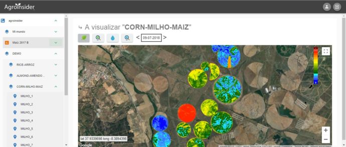
As a demonstration of the use of these platforms in agriculture we recommend that you try AGROMAP (Figure), the platform of the company Agroinsider, Lda (www.agroinsider.com).
You must access the following URL: https://agromap.agroinsider360.com/ and within it, you should put the following username: demo@agroinsider.com and as password: xptoxpto.
The use of this platform is usually intuitive. Open the DEMO folder and within explore the different crops in space and time, as well as the different satellite indices (Sentinel 1 and 2 of the ESA) with applications in agriculture, and test your knowledge.